
NASSAU, Sept 5 (NNN-AGENCIES) — Rescuers have begun to reach areas of the northern Bahamas devastated by Hurricane Dorian, with aerial images showing a trail of destruction.
PM Hubert Minnis said some areas had been “decimated” and expected the current death toll of seven would rise.
The hurricane winds that hit the Abaco Islands equalled the highest ever recorded at landfall, and Grand Bahama also suffered severe damage and floods.
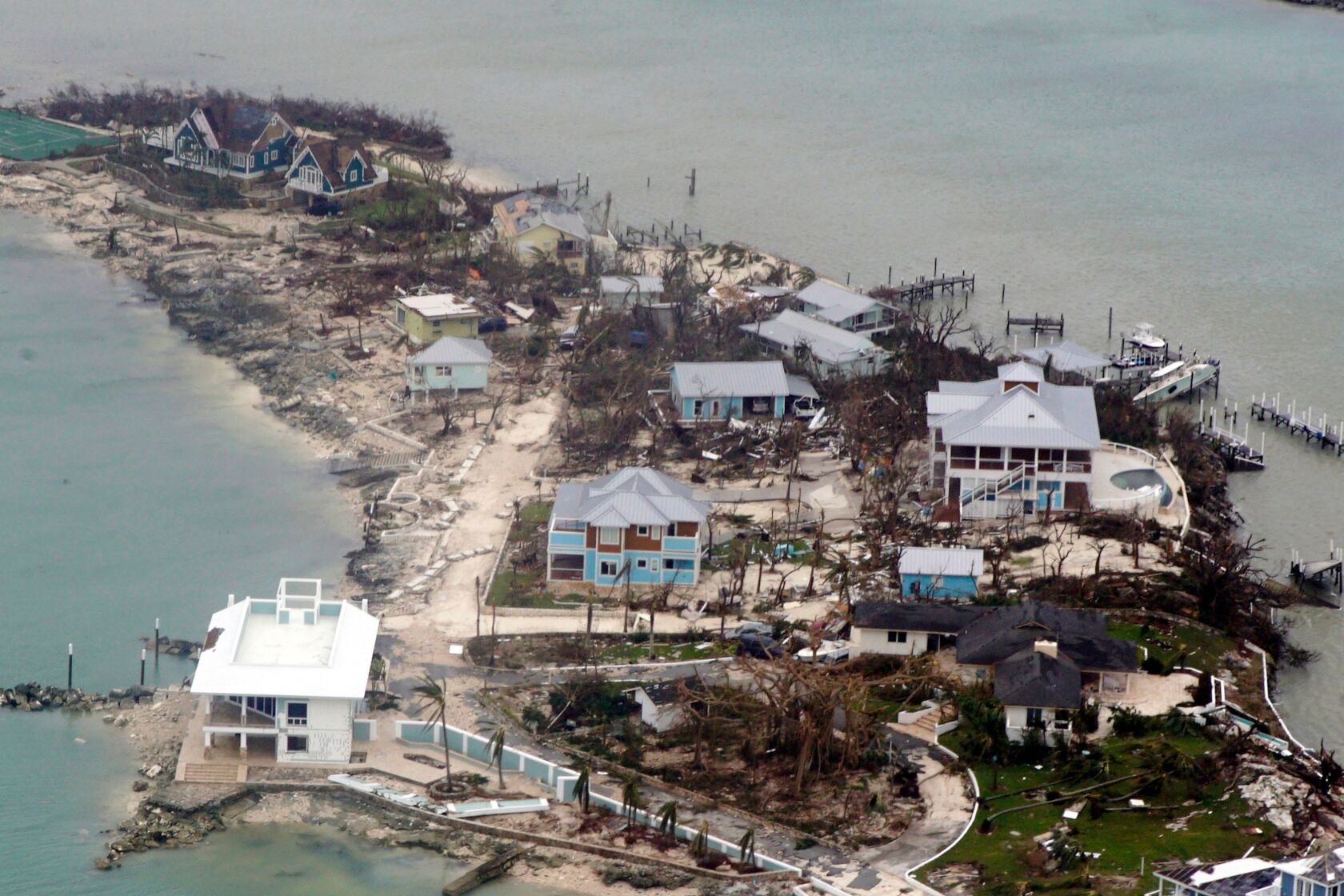
Aerial image of homes and piers in the Bahamas damaged by Hurricane Dorian.
After unleashing catastrophic destruction on the Bahamas this week, Hurricane Dorian crawled up the southeastern coastline of the United States on Wednesday, threatening hundreds of thousands of residents across low-lying South and North Carolina with severe flooding.
Dorian has moved off north but still threatens the eastern US seaboard.
Forecasters have warned it could make landfall on the coast of South or North Carolina on Thursday.
Although the hurricane has weakened to a category two storm with maximum sustained winds of 165km/h, it has grown larger in area.
Minnis confirmed the death toll had risen from five to seven, but added: “We can expect more deaths to be recorded. This is just preliminary information.”
He said the Bahamas was facing “one of the greatest national crises in our country’s history”.
Lia Head-Rigby, who runs a relief group and overflew the Abacos, said her representatives had told her there were “a lot more dead”.
“It’s total devastation. It’s decimated. Apocalyptic,” she said.
Aerial images over the Abacos, including the port town of Marsh Harbour, showed mile upon mile of destruction, with roofs torn off, scattered debris, overturned cars, shipping containers and boats, and high water levels.
Opposition leader Philip Brave Davis described the scenes from a flight over the islands as a “horrible sight”.
Parts of the Bahamas received up to 35in (89cm) of rain.
The situation on Grand Bahama is less clear, as Dorian only moved on late on Tuesday after nearly two days of pummelling, cutting many communication lines.
Most rescue work was being done on an ad hoc basis by locals using boats and jet skis, but it was being hampered by flooded roads, fallen trees and submerged debris.
Rescue teams were “beginning to get on the ground”, National Security Minister Marvin Dames said.
Minnis said: “Our priority at this time is search, rescue and recovery. It will take all of us as a caring community – government, church, businesses and individuals – to help restore the lives of our people.”
People have taken to social media to post lists of those they have lost contact with during the storm.
The International Red Cross fears 45% of homes on Grand Bahama and the Abacos – some 13,000 properties – have been severely damaged or destroyed.
Some 60,000 people will need food aid and clean water, UN officials say.
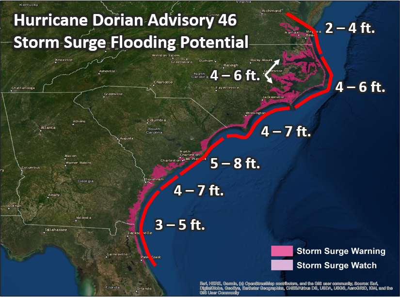
The National Hurricane Center said Dorian was located about 185km east of Jacksonville in Florida and about 180 miles south of Charleston, South Carolina.
The storm – moving at 9mph (15km/h) – would travel parallel to the Florida and Georgia coasts through Wednesday night, then “near or over” the coasts of the Carolinas through Thursday and Friday, it said.
The NHC warned there was a danger of life-threatening storm surges for coastal communities north of Port Canaveral in Florida all the way to the North Carolina-Virginia border.
Dorian is expected to weaken over the next few days but will remain a powerful hurricane.
President Donald Trump tweeted that the US “may be getting a little bit lucky with respect to Hurricane Dorian, but please don’t let down your guard”. — NNN-AGENCIES


