
CANBERRA, Nov 21 (NNN-AAP) – Researchers have conducted the deepest archaeological survey in Australian history, to map a sunken Japanese World War II submarine.
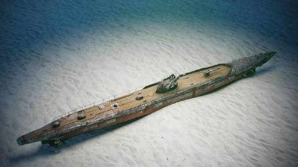
After three years of work, a team from Australia’s Northern Territory (NT) government, has created a 3D model of the Japanese I-124 submarine, by using specialised cameras mounted to underwater scooters.
The I-124, with 80 crew members on board, sank off the coast of Darwin, the capital of the NT, in Jan, 1942, after being struck by depth charges deployed by the Royal Australian Navy.
Only weeks after the submarine was sunk, 236 people were killed, during the Bombing of Darwin, according to The Australian Broadcasting Corporation.
Due to strong tides, murky waters and the submarine’s depth of 50 metres, no survey of the site had ever been attempted, until a team led by David Steinberg, the NT government senior heritage officer and maritime archaeologist, explored it.
Steinberg described the expedition as a major breakthrough.
“The level of accuracy and detail that’s been captured is just remarkable, with these new technologies and new advances in maritime shipwreck mapping,” he told News Corp Australia.
“It’s got us so much new information, it’s basically a game-changer in how we understand our shipwreck resource.”
The 3D model will be used to determine how quickly the site is deteriorating and what can be done to preserve it.
Findings have been shared with the Japanese authorities, and a container of sand from the seabed was to be shared with the families of the crew.– NNN-AAP


