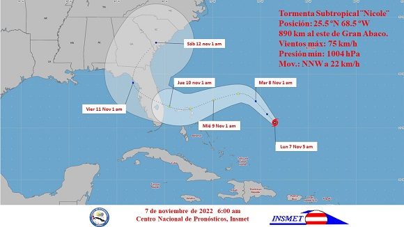
HAVANA, Nov 8 (NNN-ACN) — The extensive area of low pressure located in the seas north of Puerto Rico continued to gain in organization and intensity during the early morning and became a subtropical storm named Nicole, the Cuban Institute of Meteorology reported.
The Tropical Cyclone Warning No.1 of the Institute’s Forecast Center states that Nicole has maximum sustained winds of 75 kilometers per hour, with higher gusts, its central pressure is 1,004 hectopascal and it is moving north-northwest at about 22 kilometers per hour.
According to the forecast, at 5:00 a.m. its central region was located at 25.5 degrees north latitude and 68.5 degrees west longitude, a position that places it 890 kilometers east of Great Abaco Island, northern Bahamas.
Over the next 12 to 24 hours, the subtropical storm will move in the same direction, inclining its trajectory to the northwest and slowing somewhat, gaining more organization and intensity, with the possibility of becoming a tropical storm in the next 48 hours.
The Cuban Meteorology center keeps close attention to the unfolding of sub-tropical storm Nicole moving on the waters north of Cuba and threatening as it approaches the Bahamas and the US Florida Peninsula.
Nicole is expected to reach The Bahamas on Tuesday as it will gain strength, organization and intensity before hitting the eastern coast of Florida Wednesday night.
Cuba is under the impact of the large rain circulation of Nicole, which means rains in the eastern and northern sections of the island. So, rains will cover the central and western Cuban regions and could turn heavy and locally intense, according to the meteorology institute, which alerts about winds with up to 25 to 40 kilometers per hour and high gusts as of Wednesday.
According to the NHC advisory about the storm at 7pm, the center of Subtropical Storm Nicole was located near latitude 26.7 North, longitude 70.8 West. The storm is moving toward the northwest near 8 mph (13 km/h) and this general motion is expected to continue through tonight. A turn toward the west or west-southwest is forecast to begin on Tuesday and that motion should continue through early Thursday.
On the forecast track, the center of Nicole will approach the northwestern Bahamas on Tuesday and Tuesday night, move near or over those islands on Wednesday, and approach the east coast of Florida Wednesday night.
Maximum sustained winds are near 45 mph (75 km/h) with higher gusts. Some slight strengthening is forecast tonight or Tuesday, with a faster rate of strengthening expected Tuesday night and Wednesday. Nicole is forecast to be at or near hurricane intensity by Wednesday or Wednesday night while it is moving near or over the northwestern Bahamas. — NNN-ACN


