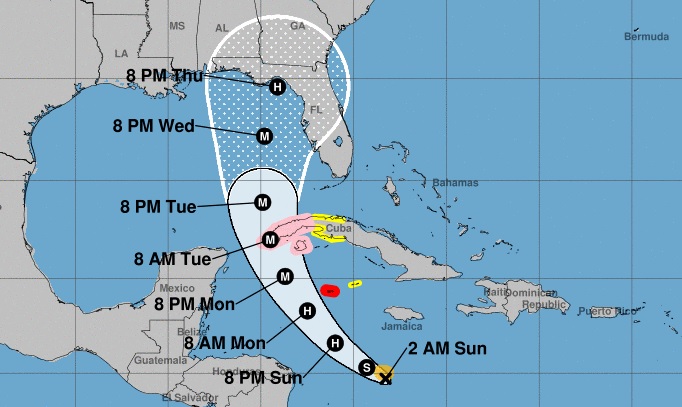
HAVANA, Sept 26 (NNN-ACN) — As it passes through the central Caribbean Sea, Tropical Storm Ian gained slightly in organization and intensity Sunday night, and now has maximum sustained winds of 85 kilometers per hour, with higher gusts, and a central pressure of 1,002 hectoPascal.
Its movement remains on a westerly course, decreasing the speed of translation to 20 kilometers per hour, says the Institute of Meteorology of Cuba in its Tropical Cyclone Warning No. 8, issued at 12:01, local time.
According to the report, at midnight Ian’s central region was estimated at 14.7 degrees North latitude and 77.9 degrees West longitude, a position that places it in the waters of the central Caribbean Sea, some 630 kilometers south-southeast of Caiman Grande and 855 kilometers southeast of Cayo Largo del Sur.
In the next 12 to 24 hours the tropical storm will begin to tilt its path between west-northwest and northwest, with similar speed of translation, rapidly gaining in organization and intensity, with the possibility of reaching hurricane status this Sunday.
Due to the potential danger it represents for western Cuba, the Forecast Center of the Institute of Meteorology is keeping a close watch on the evolution of this tropical cyclonic organism, the warning states.
It adds that given its position and the forecast trajectory, tropical storm Ian could provoke strong winds, heavy and intense rains and coastal flooding in low-lying areas of the southern coast starting on Monday, September 26, in that part of the Cuban territory.
Meanwhile, authorities and residents in Florida, US were keeping a cautious eye on Tropical Storm Ian as it rumbled through the Caribbean on Sunday, expected to continue gaining strength and become a major hurricane in the coming days on a forecast track toward the state.
Gov. Ron DeSantis declared a state of emergency for all of Florida the previous day, expanding an initial order that had covered two dozen counties. He urged residents to prepare for a storm that could lash large swaths of the state with heavy rains, high winds and rising seas.
Forecasters are still unsure of exactly where Ian could make landfall, with current models plotting it toward Florida’s west coast or panhandle regions, he said.
“We’re going to keep monitoring the track of this storm but it really is important to stress the degree of uncertainty that still exists,” DeSantis said at a news conference Sunday, cautioning that “even if you’re not necessarily right in the eye of the path of the storm, there’s going to be pretty broad impacts throughout the state.
President Joe Biden also declared an emergency, authorizing the Department of Homeland Security and the Federal Emergency Management Agency (FEMA) to coordinate disaster relief and provide assistance to protect lives and property. The president postponed a scheduled Sept. 27 trip to Florida due to the storm. — NNN-ACN


